Settlement in Garrafrauns Area.
The sites of ring forts, liosanna or Raths in the area suggest that people settled in this locality in ancient times from c 400 AD to 1200 AD. These forts have earthen banks; some are fac ed with stone while a couple were constructed totally of stone (Cahir). Some of the forts are sited on isolated hills or eskers. They were the defended farmsteads of the native Irish, a defence from hostile neighbouring clans and the wild animals that roamed the forests. The settlements were centres of a mixed farming economy and were largely self sufficient in the production of food, tools, textiles and household goods. Surrounding the settlement was an earthen embankment and ditch(Fosse). The more important the fort the greater
number of embankments. On top of the embankment stood a stockade of wooden stakes. The settlement was usually dominated by a large round wooden house constructed of wattle and plastered with daub. The roof was constructed of branches, heather and rushes. Several outhouses and animal pens stood against the outer wall. Beneath the settlement were excavated tunnels and souterrains which were used as storage, as a place of refuge and as a means of escape.
During the 1600’s after the Plantation of Ulster many Catholics were forced out of their fertile homesteads by their new Protestant neighbour . They were to flee to the less fertile marginal land of Donegal, and Connaught to start new homes. Still some of the lands around Garrafrauns was sparsely populated. These areas were mostly rock strewn, covered with briars and blackthorn. Other areas were covered with pine forests. The forests extended from Cloondalgan into Quinaltagh. An area of Quinaltagh is known as Laughill (leath-choill)meaning “half wood”. A survey at the time identified 210 acres of bogland, 27 acres of rock and 2.5 acres of water.
By the 1750’s many of the old style landlords were beginning to die out. Some had lost their estates through bankruptcy, marriage disputes or were simply dispossessed. New types of landlord and merchant classes started to emerge and were motivated by profit and greed. Penal laws were being relaxed, agriculture was booming and prices for food commodities were high. To avail of this prosperity from the land, landlords through their agents brought in people to work and till the soil and reclaim forests, mountain scrub and marsh lands.
Other landlords owned extensive estates suitable for grazing cattle; consequently people were moved off the land to less hospitable places. Another factor was the increasing importance of bog land as a source of fuel for people in the towns and cities. Landlords brought in people to work the bogs thus contributing to their profits.
 stone wall in Quinaltagh
These factors contributed to the mass migration of people from one area to another especially in the north and west of the country. All of this accounted for a big upsurge of population in the Garrafrauns area from the 1750’s onwards. It appears that Shanballymore, Cloondergan, Cappagh and Cloonkeen were settled first, then Dalgan, Corohan, Ardcloon and Gortnagoyne. Finally the area between Quinaltagh, Cloonbrisk, Cloonfane, Garrafrauns, Addrigoole and Gortnalea.
The people who settled in this area were also of Northern decent and were referred to as Ultachs. The townland names of Quinultach and Baile an Ultach are testament to this. Originally they were evicted from the Bann Valley in Antrim and settled in the Gore Booth Estates of Sligo and North Roscommon. To facilitate grazing of cattle and sheep on these estates they were moved to this area. Tradition tells us that the people were so traumatised by the sight of their new surrounding they lamented for their former homes. The Gaelic names Quinaltagh (lament of the Ulster people) and Cloonkeen ( Sorrowful meadowland) testify to this fact.
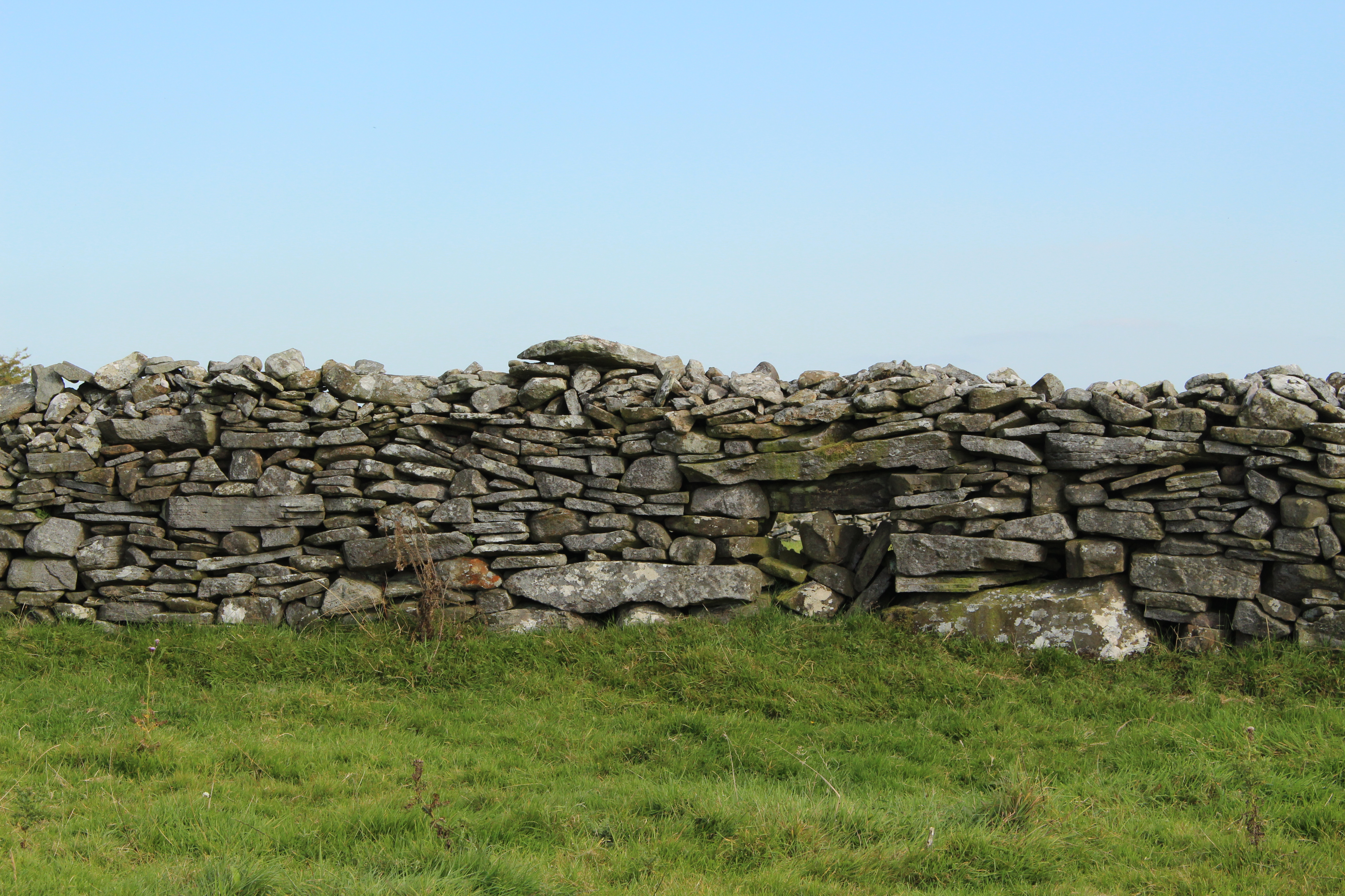
On arrival the tenants erected a cluster of rough dwellings close to the existing ringforts of the area and proceeded in the back breaking work of clearing the rock strewn hillside. Farms were courageously established from this stoney land and soil for the sowing of their staple diet of potatoes and oats was in very short supply in the area. Such was the huge amount of unearthed stones; the only way they could be disposed of was in the construction of walls up to 10 feet tall and 8 feet wide. The larger flag stones were placed on the outside with the smaller stones in the centre. Many of these massive stone structures can still be found in the area.
Land clearance in the mid 1800’s at Hollymount, Cloghans Hill and the Deerpark and Blindwell villages in Kilconly by the Miller family resulted in tenants being relocated to Cloonfane and Quinaltagh where the landlord Richard Kirwan owned less profitable ground, The Kirwans and Millars were related through marriage. Glynn, Mullins, Hernon and Flanagan families were moved into Quinaltagh at this time.
The people of this area suffered greatly during the 1800s and the population was decimated by the Great Famine of 1845. After the famine corn prices which was the main currency of the people had plummeted so many landlords increased the rent or cleared their estates for cattle
A wave of evictions forced many families onto the side of the road. It is said that 13 families were evicted from Cloonfane on one day alone and the population of the village dropped from 365 to 160 in 10 years. Threatened evictions in Quinaltagh sparked the monster meeting in Irishtown where Michael Davitt formally launched the Irish Land League. Emigration became the new scourge of the area right up to the 1960's. Due to lack of employment hundreds of young men and women were left with no option to emigrate to the U.S. and England.